Showing posts with label Shropshire. Show all posts

Saturday, 21 December 2019

The Mere Cremone Gardens

To continue my stroll by the side of The Mere from the previous post I'll start with this Wood Pigeon chilling out.
The sun was against me to capture 'Secure' (made of steel and oak) by Nick Horrigan so maybe I'll pass the view off as moody.  Next
Its so quiet -sshhh. 
The artist John Merrill was inspired to create the wooden SShhh by the peace and quiet of the beech avenue at the end of Cremone Gardens. Originally made of local lime wood the weather eventually took its toll so he has re-carved and replaced the letters in good old sturdy oak. The utility vehicle was also quiet however its driver was hard at work with a leaf blower keeping the path clear. He had come prepared for in the yellow bucket was something most welcome on a chilly and windy day, a hot drinks flask. His leaf blower was turned off when we reached the sculpture and he
waited until I had taken a picture of the decorated holly tree and passed him to retrace our steps
for the path beyond in the woods was very muddy not the place for someone wearing the wrong footwear.
Or to go beyond the gate to the Fishing Pod to gaze over the waters. I believe there is a family of otters living on The Mere - no need for them to join the EAC (Ellesmere Angling Club) for these natural catchers of fish have carte blanche

Links

Ellesmere Sculpture Trail - John Merrill
Ellesmere Sculpture Trail - Nick Horrigan with a much better photo.

Thursday, 12 December 2019

Bee Metropolis

A willow by a mere on a rainy and blustery day in Shropshire. The place is Ellesmere and the area contains the largest natural glacial meres in England outside of the Lake District, which of course are on a grander scale. The mere here (Old English for Sea Lake) is perfectly formed and simply called The Mere.
The waters are surrounded by interesting trees and also
on a hill is a Bee Metropolis, hoping to give bees a helping hand
The slowly moving sculpture was being rotated by the breeze and is by local artist Caroline Lowe who wove a willow sculpture representing a Wool Carder Bee (Anthidium manicatum)

and this honeycomb shaped sign shows it and its plant of preference.
The logs the willow bee rises above have been drilled with holes to make homes for solitary bees and other invertebrates.

Links-
1. Ellesmere abuzz over giant bee sculpture - artist and bee
2. Caroline Lowe


Tuesday, 28 July 2015

Coracle

A boat one can pick up and carry, the ultimate in portable transportation.  We passed the time of day with this man carrying his coracle down to the River Severn in preparation for the annual Ironbridge Regatta in August which always includes a coracle race.  Despite the fact that Wales is the first place I think of  in association with coracles Shropshire seems to be a coracle hot spot with world championships and coracle making courses put on by the Small Woods Association.

This simple design of a flat bottomed boat made of willow and a waterproof skin has been used for thousands of years but they differ in style from place to place to accommodate different river conditions.  The Rogers family made coracles here by the River Severn for generations, the last of them, Eustace Rogers, died in 2003 and the shed where they were created lay empty and decaying, however the sum of money required to restore and repair the shed to tell the story of the Rogers family and coracle making was recently raised by the Ironbridge Coracle Society.  Until the volunteers put in the hours of work there is a website to browse called - the coracle shed.

These craft are notoriously difficult to control for the amateur as they sit on the water rather than in it and are known for being unstable, however a fisherman can row one of these with one hand while the other hand manages the net with ease.

Here is an old postcard of a rather full looking River Towy over the border in Wales and its coracle men in and out of the water.
         
An entry to ABC Wednesday, a journey through the alphabet, this week mooring up at C here


Tuesday, 5 May 2015

Quatt

St Andrew's Church, Quatt
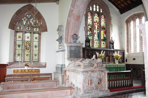
For any history lover St Andrew's Church in Quatt has a fascinating interior full of plaques, tombs, coats of arms and memorials but on top of that it is very pretty with its pink and grey marble and sandstone features. The great and the good are memorialised with the local Wolryche family featuring large (the tomb above is of Margaret and and Francis)
Memorial to George Wolryche, younger brother of the 1st baronet
They even had a reforming politician in their number,  William Wolryche-Whitmore (1787-1858), who campaigned against the Corn Laws and slavery and is buried in the churchyard but memorialised in some length in the church.
One would never guess from such a plain exterior there was so much crammed inside.
Lieutenant Thomas Orde Lawder Wilkinson VC
Outside by the path I came across this Canadian flag and thought it must be someone on a quest for their ancestry but this was not the story. Lieutenant Wilkinson had emigrated with his family to Canada from Lodge Farm near Quatt. He enrolled with the Canadian army on outbreak of World War 1 but when he was not sent overseas made his own way to England and joined the North Lancashire regiment. The posthumous owner of the Victoria Cross his body was never recovered and is commemorated on the Thiepval Memorial to the Missing on the Somme who have no known graves. This plaque was placed in Quatt churchyard after unsuccessful attempts to trace any relatives by the Shropshire War Memorials Association. (Source: Wikipedia)
As one walks down the path on the way out opposite St Andrew's church at Quatt is a large house.   Originally built as the Dower House in the 18th Century I learnt from the 'Workhouses' site it was, as the result of the Poor Law Amendment Act,  turned into a school for pauper children. In 1851 it housed 170 girls and boys, its 4 acres of land provided income, the boys cultivating the land and looking after cows and pigs and the girls working in the house and dairy.  A gazetteer of this date extolled the "habits of industry, knowledge of gardening combined with honest principles and religious knowledge are blessings of incalculable amount" which the inhabitants obtained. At its peak it would educate 220 pupils but was closed by the 1900s probably because by that time there was state funded free schooling for all up to the age of 12.  It would later become an independent primary school which went into liquidation in 2010, today I believe it has been turned into seven residential apartments.

What a lot of history within a few steps in a village of a couple of hundred people but the settlement is very old. The curious name derives from the Celtic word for wood - Coed and the Saxon word for farm - Tun.  That is Coed-tun - "The village in the wood".  By the time of the Domesday Book of 1086 it was listed as Quatone which has through the centuries morphed into the name of Quatt.

An entry to ABC Wednesday, a journey through the alphabet,  this week sojourning at the letter Q here

Tuesday, 10 March 2015

Inclined Planes


Historically Inclined Planes were used extensively in the Ironbridge Gorge to move heavy objects up and down slopes but mostly all that endures are indentations and grooves running down forested hillsides; however for those interested in Industrial archaeology the Hay Inclined Plane remains to show the infrastructure required to move tug boats up and down a hill.  I believe from rail buffs that these are not the originally rails that would have been used from 1792-1894 but some British Rail cast offs from the national railway system.  Also we need a modicum of imagination for I have been unable to find photographs or drawings of the box shaped tug boats being moved the 207 feet (63m) by gravity, one ascending and one descending on roped up wheeled cradles on the rails from here -


the Blists Hill waterway down to the

Coalport Canal (part of the Shropshire Canal system)
 
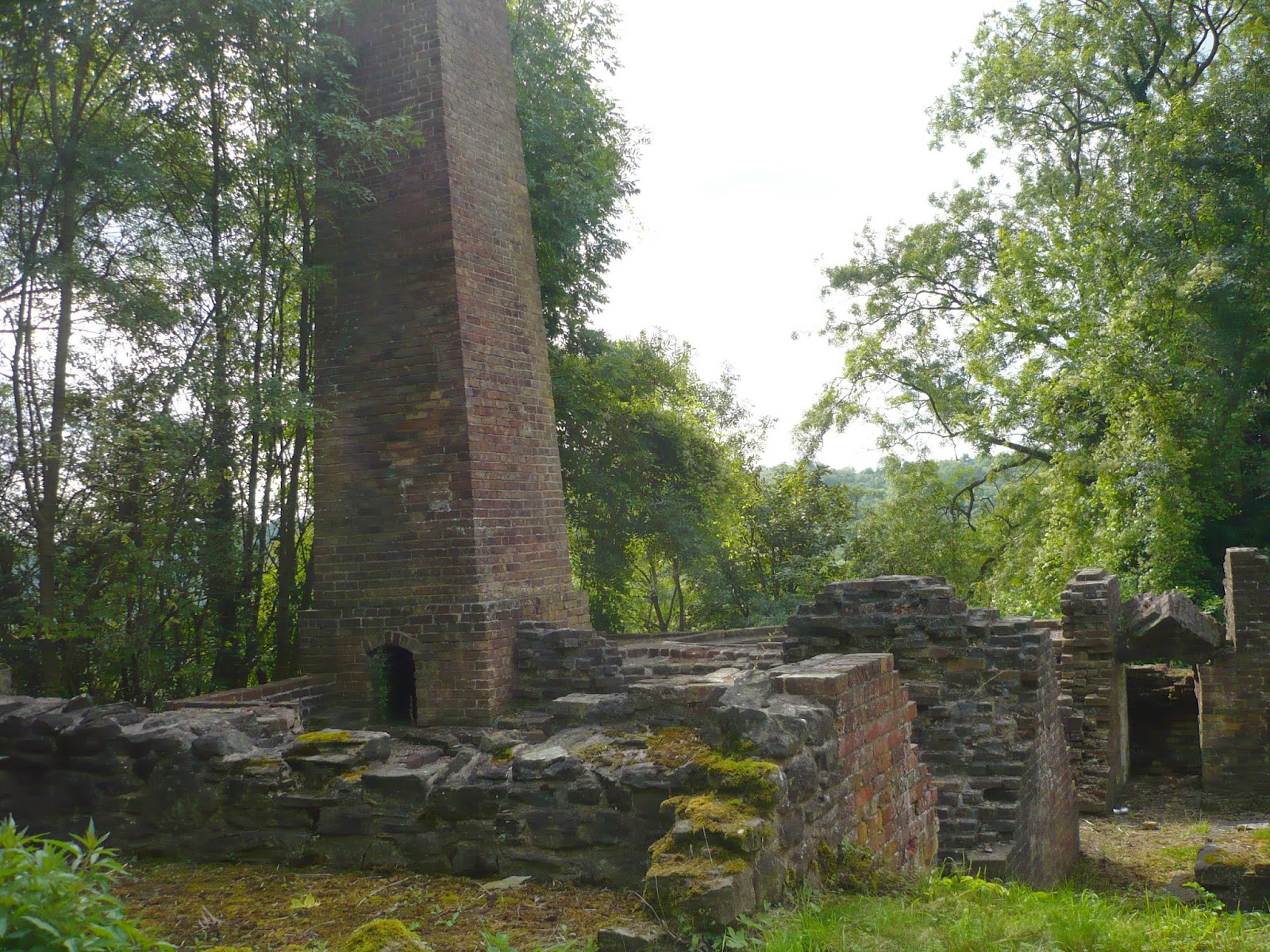
This is the point the tug boats would have run down and into the canal, still on the tracks, which looks rather dishevelled today.  Although the loaded boats were travelling downhill by gravity the brakes were operated by a winding drum operated by a small steam engine in this engine house
And here is a view of the unreconstructed rail system of the other track
It would be nice to see it running but from the Blists Hill miners track you can take a ride down an other inclined plane in another direction  
from the upper waterway whatever the weather in comfort sat in a trolley which leads to a re-creation of a Victorian Fair where one can indulge in a variety of rides.

An entry to ABC Wednesday, a journey through the alphabet, this week sojourning at I here


Tuesday, 3 March 2015

Hampton Loade

This bridge's distinctive and pleasing shape attracted my attention when I'd seen it in the distance from a train window so why not take a walk along the river to take a closer look. It is the Hampton Loade Bridge to the Water Treatment Works over the River Severn. The tubular blue archways integrated into the bridge are water pipes with a walkway underneath.. The water treatment plant and nearby Cheltmarsh Reservoir were built in the 1960s by Degremont-Laing for Severn Trent Water and it was the first design and build contract for the then national and publicly owned water industry.  (Previously capital projects employed a consultant engineer to carry out a feasibility study and then project manage the resulting contracts).  With privatisation  design and build contracts became the norm.

This stretch of the River Severn is popular with canoeists although I wasn’t quick enough with my camera to catch them going under the bridge.  We didn't inspect the bridge further as our route led us further along the banking (and as it turned out into a thunderstorm) but we did look longingly at

the landing stage across the river on the way past where we had heard the cable ferry ran although the machinery didn't look well used.
however the wiring was still in place nearby
along with the water measurement pole.  The crossing has been here for about 400 years but the floods of 2007 damaged the riverbank and I wondered how far up the pole the water reached.  The owner put the ferry up for sale after the floods and I read that the Hampton Loade villagers now operate the crossing. With the help of Wikipedia here is the ferry in operation 
"Hampton Loade Ferry - 2004-07-24" by © Optimist on the run, 2004 /. Licensed under CC BY-SA 3.0 via Wikimedia
and this is the explanation of its workings.  "The Hampton Loade Ferry is a reaction ferry, propelled by the river current.  An overhead cable is suspended across the river, and the ferry is tethered by a second cable, to a pulley block that runs on the suspended cable. To operate the ferry it is angled into the current, causing the current to move it across the river".

 An entry to ABC Wednesday, a journey through the alphabet, this week sojourning at H here


Tuesday, 20 January 2015

Benthall Edge Woods

A few days before I took this photograph the cricked back I'd had for months had suddenly and unexpectedly shuffled everything back into place like a row of dominoes and I felt like bounding up these steps in celebration.  Needless to say I didn't make it to a bound but walked sedately up through Benthall Edge Woods.  Many paths converge here and it is a popular woodland walk so the steps both protect the woodland environment and the walker from sliding on muddy slopes
I have been told there are 469 steps in total but didn't count them.
Despite plenty of signposts (none of which were the one we were looking for) we managed to miss part of the purpose of the walk which took in the remains of the industrial revolution, an old quarry and lime kilns
Somehow ending up out of the woods amongst baby bovines
Coming down through the woods and dropping onto the route of the Shropshire Way on the way back
where we eventually saw one lime kiln just off the Severn Way footpath but there was some construction work going on so sadly we couldn't approach, however the late summer woodland greenery more than made up for the disappointment.  This part of the Severn Way long distance footpath runs along an old disused railway line
which no doubt would be marked on this information board of the area that was being drilled into place by the side of the car park on our return.

An entry to ABC Wednesday, a journey through the alphabet, this week sojourning at B here


Tuesday, 13 January 2015

Abbey to Abbey

Near the Severn river in peaceful surrounding stands Buildwas Abbey, although its past was not always as serene as it looks because it is near the border of Wales and battles between the Welsh princes and the English took place in this area.  One incident was the kidnapping of the abbot in 1406, although perhaps an abbot should be wary here for one was murdered by a monk.
The abbey was founded in the 12th Century as a Savignac order which within a few decades merged with the Cistercians.  When I wandered around the grounds at Buildwas I did not realise there was a connection with the abbey of my home town, for it was a group of monks from Furness Abbey that were sent here to establish Buildwas Abbey.
Furness Abbey also lies in peaceful surroundings (here seen in the Autumn light which highlights its beautiful sandstone). It too was in a border country only this time it was the Scots that were likely to raid and it too would fall into ruin with the Dissolution of the Monasteries by Henry VIII,
The architectural details are more ornate at Furness Abbey but it was one of the richest abbeys in the land and also built some time earlier, so perhaps more influenced by Norman or Romanesque architecture whereas  
Buildwas was showing the development of a distinctive Early English style.  Like Furness the Buildwas stone is interesting for it is of different shades and alters with the light.

An entry to ABC Wednesday, a journey through the alphabet, which has reached its 16th birthday and this  this week is starting all over again at A here.