Showing posts with label Viaduct. Show all posts

Tuesday, 22 March 2016

River Kent

The River Kent starts its life in the Kentmere valley, here it is weaving its way through the town of Kendal, about nine miles away, in benign manner.  Not so recently, the winter storms saw the water level rise, and keep rising, eventually flooding the riverside walk and the houses alongside it.  The many bridges that cross the Kent
had to be checked for safety, one closed,
This footbridge is the most modern of the bridges.  The Kent is a short river (20 miles) but one of the fastest flowing in the spring wending its way over weirs and waterfalls and through villages
but here it is on a still autumnal day placid in the sunlight passing through the Levens valley while
sheep graze
and goats keep a curious eye open.
Kent Viaduct at Arnside
Eventually it will reaches Morecambe Bay, mingle with the salt water 

 and head out with the tide into the Irish Sea.

 "You could not step twice into the same river" (Heraclitus)

An entry to ABC Wednesday, a journey through the alphabet, this week sojourning at K here
 

Tuesday, 14 January 2014

Arnside on the Rails


Built in the mid 19th Century I think the view has altered little on Arnside Station since then, apart from the station furniture.  All is quiet until

a bust of activity as passenger arrive at Arnside Station, crossing over the bridge and heading for the way out on a summer's late afternoon.  I was waiting for the train going in the other direction.  When I do board the train just a short distance west over the blue sea in the distance

is the Arnside viaduct.  The signal is up and the Barrow to Manchester Airport train, a distinctive Desiro DMU is taking them home.    
The 50 span and 1,558 ft Arnside Viaduct crosses the Kent estuary (low tide when this photo was taken).  The viaduct, built in 1857, was repaired and refurbished in 2011.
Low Tide Channels, Arnside Viaduct, Morecambe Bay

 An entry to ABC Wednesday, starting a new journey through the alphabet and a new logo, its Round 14


Wednesday, 7 August 2013

Dandry Mire


 I'm a little late this week for ABC Wednesday as I just arrived home today but at least it is still Wednesday. Let me take you on a walk past Dandry Mire viaduct, 12 arches and 50 foot high; built in the 1870s it forms part of the Settle to Carlisle railway.  The small building in the distance on the left is a chapel

built for the workers on the railway here which at that time was called Hawes Junction but it has long since been renamed however the chapel retains its original name of "Hawes Junction Methodist Chapel". You also may make out a very tiny splash of yellow near the left hand end of the path on the first photo which was attracting a cloud of

these little fellows which I think are Mother Shipton moths (Callistege mi). Do I imagine that the pattern at the edge of the wings are a little like viaduct bridges? Their colour in the sunshine was more like a light mauve than this photo shows. A stunning sight.
Going around the other side of Dandry Mire viaduct shows its curve, and here is a

'sprinter'  train barrelling along the track. The story goes that originally the crossing of Dandry Mire was planned to be an embankment but wagon loads of material later (¾ m cubic feet) and it all disappearing into the mire or bog a viaduct was built.
River Ure and Wild Boar Fell   
At the moment after weeks of hot weather and little rain it is a surprisingly dry bog in relative terms although still enough water around.  This peatland is a unique habitat and
the waterfalls show how the peat mixes as they make their way down the fells
One end of the viaduct embankment is a road bridge over the A684 with nicely themed supports. No border patrols but this does mark one, on this side of the bridge it is Yorkshire but drive through and you are in Cumbria.

An entry to ABC Wednesday - a journey through the alphabet

Tuesday, 15 March 2011

ABC Wednesday - Ingle

 Ribblesdale
Today I'm taking you to the Yorkshire Dales on the road that crosses the Pennines, the dividing point of east and west in the north of England. A popular run out for bikers, who lean into a incline position to go round the bends. In the background is the Ribblesdale Viaduct which carries goods and passenger trains from Settle to Carlisle.
So as the train crosses the valley, rising in the background is the 2372 bulk of Ingleborough. On its flat summit is the remains of an iron age fort. An ideal place to see all the surrounding countryside.  At the foot of Ingleborough lies 

 the village of Ingleton. a popular tourist destination and walking base. The church on the hill is St Mary's whose oldest artefact is a 800 year old Norman font, found in the river just over a century ago. I wonder which part
 of the River Greta it was hidden.  The Ingleton Viaduct spans the Greta Gorge with its 11 arches. It was completed in 1859 and the village had two railway stations because there were two competing railway companies. However the line is now disused and unlike the other historic viaducts of the area it is not accessible so I content myself with taking pictures from the ground.
The traditional Dales cottages huddle near its arches.
in the hollow of the valley, on this side a farm and caravan park. No trains to watch except in
past photographs. Date unknown, but the locomotive pulling the passenger carriages looks very old.

ABC Wednesday has illimitable words starting with the letter L

Tuesday, 15 June 2010

ABC Wednesday - Viaduct

Let me take you on a trip round some of the 
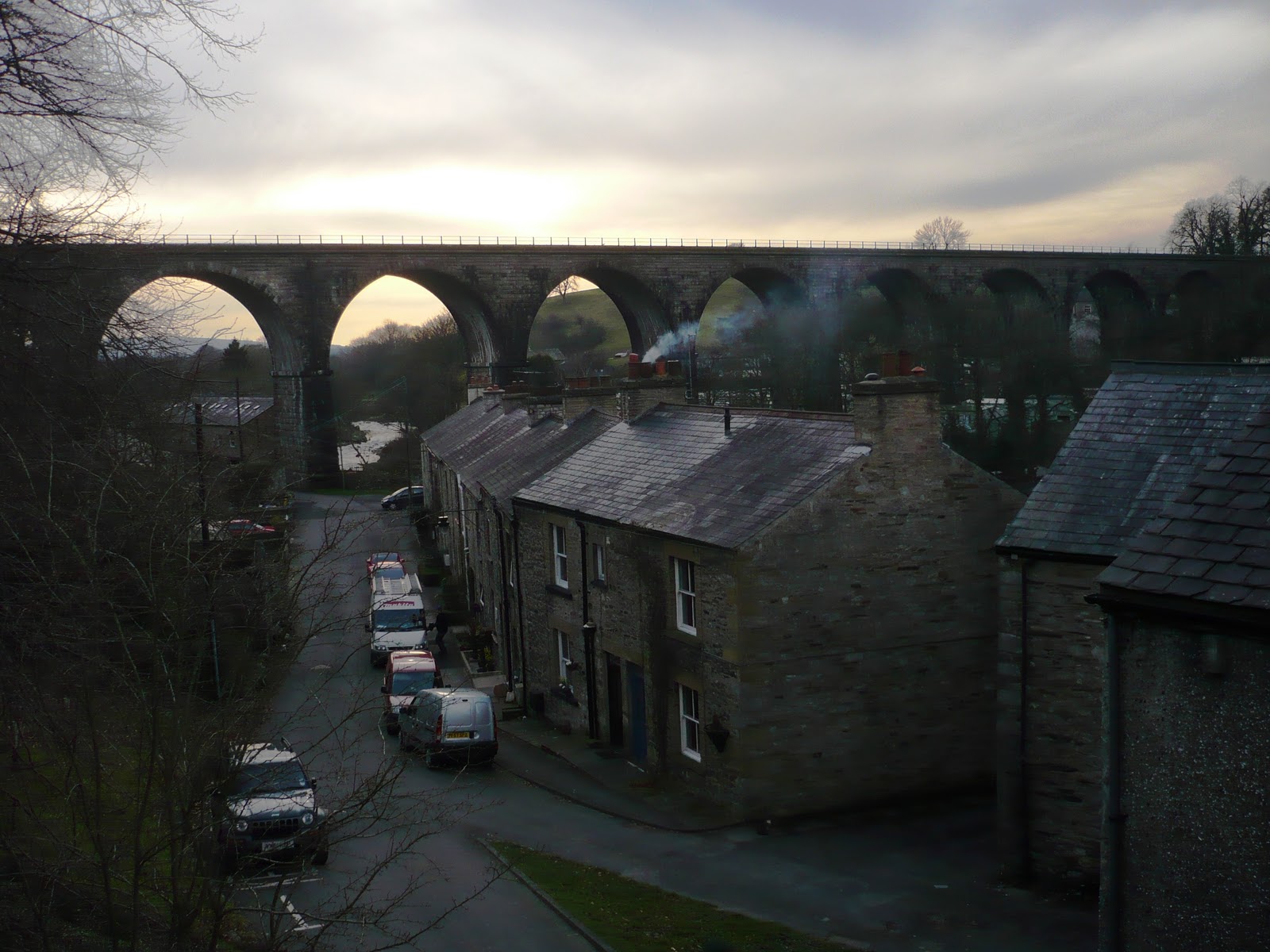
vintage viaducts in the east of Cumbria. The most perfect of them rides across its surroundings and nestles down in what is now the Smardale Gill Nature Reserve. This Grade II listed structure, 90 feet high, 184 yards long with 14 arches, was designed in 1861 by Thomas Bouch (probably more famous for his disastrous construction of the Tay Bridge which collapsed in high winds).  The Smardale Viaduct was built for the South Durham & Lancaster Union Railway which crossed the Pennines to take coke from County Durham to the iron and steel furnaces of Barrow and West Cumbria. At its peak, in the 1880s, the volume of one million tons of coke a year were transported along the line.  When Barrow steelworks closed in 1962 so did the railway.
Thanks to the formation of the 
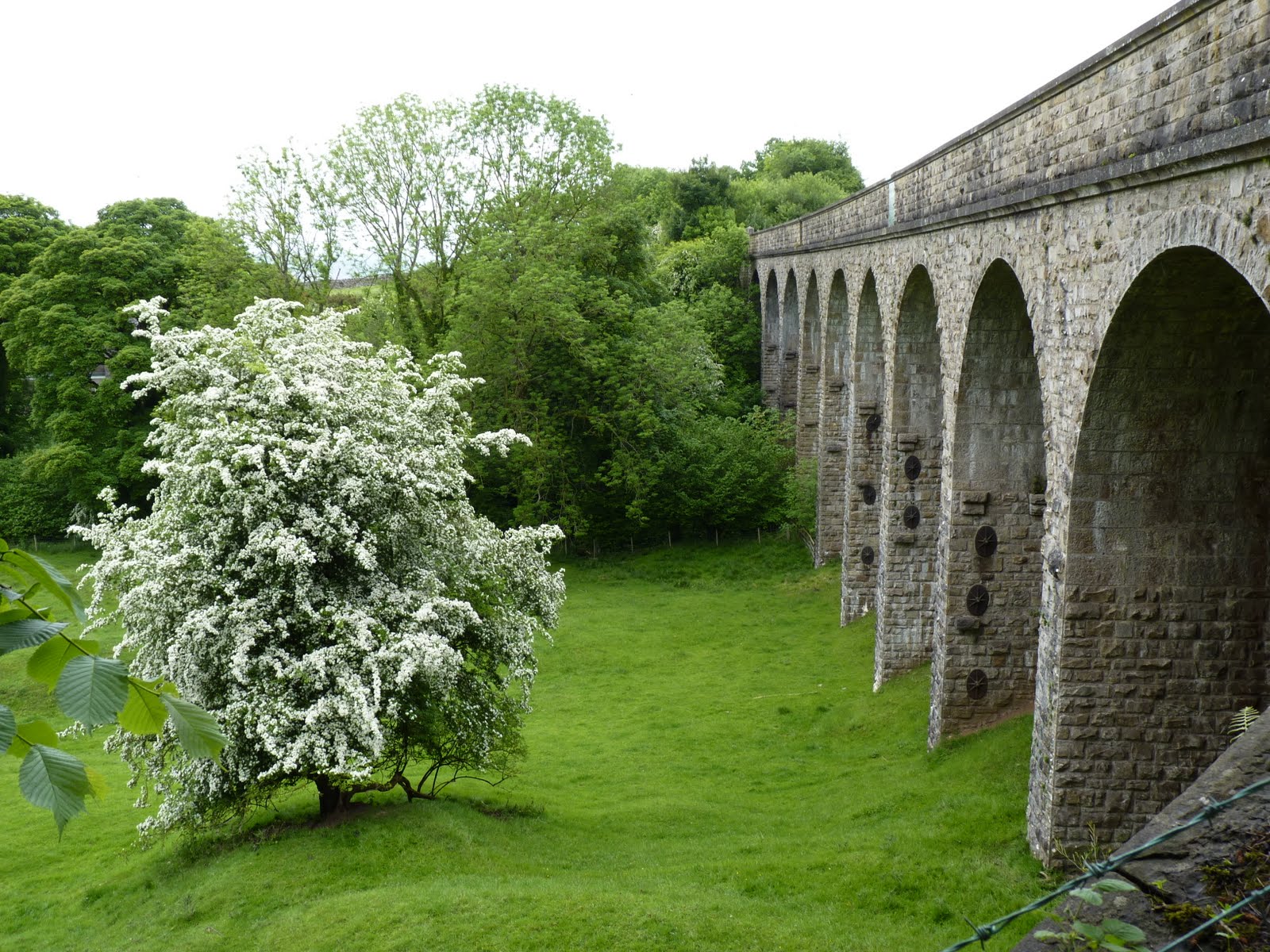
Northern Viaducts Trust in 1989 this and other viaducts were restored and saved. The original stone was all quarried locally.  Which is also the reason this nature reserve is so important
both for its limestone which supports many rare plants and invertebrates and also the sandstone on another side which sometimes merges with the limestone and becomes brockam.
 Limekilns, visible in the top of the photo, (who could resist the contrast with the blossom) were used to burn limestone to make lime which could be spread on fields to neutralise acidity in the soil, my Uncle Charlie used to say it was like sprinkling sugar on the land.

Scandal Beck which runs below the viaduct after weaving its way through the woods rolls down the verdant valley and is home to many creatures, the walkers on the bridge are seeing if they can spot anything
such as the white clawed crayfish, thankfully not not the same size as the way-sign, although it would be easier to spot.

Are you thinking "but what about the viaducts".  OK here is another one
 the Merrygill Viaduct, nine arches of 30 feet span.  Not as easy to photograph you have to scramble down the steep side and then haul yourself back up by the fence, which luckily only has barbed wire on the top. It is pleasing  to see the bends in the wire where other hands before you have done exactly the same thing.
The old railway track is now a walk which takes you to the Podgill Viaduct, this is the view from the picnic tables where victuals can be consumed, an idyllic place with the birds chirping away and the trees sheltering me from the drizzle of rain.  No sign of the native red squirrels but we did spot two resident macaws flying overhead from nearby John Strutt Conservation.Trust.
The Smardale Gill Viaduct was built as a double track but it only ever had one track, however the Podgill Viaduct was built as a single track and then they had to widen it, notice the two different types of stone.  The statistics are, eleven arches crossing Ladthwaite Beck at a height of 84 feet.
The trail then leads on the the Poetry Path, (poet Meg Peacock and artist Pip Hall) with a variety of shapes, stones and script.  The verse says
"Squirrel is speaking his mindknapweed purples the banks/ for touch, taste, small, sight, hearing/ 
I give thanks"

And leads this time to a bridge, not a viaduct, over the River Eden, one of the few large rivers in England flowing north. The fracture in the earth's crust here means the river has disappeared down the Coopkarnel, a Danish word for cup-shaped chasm, or perhaps, so I can get another v word in, a vent.
Here is the end of the walks of the northern viaducts trust so take a seat and venerate  those that built the structures and the nature that surrounds them.

Take a Visit to the other participants in ABC Wednesday and see lots more words beginning with V.