Showing posts with label Mountains. Show all posts

Monday, 12 April 2010

Tarn and Hills


Wonderfully warm April weather, the roads were lined with Daffodils as we journeyed to Coniston.  Everyone was enjoying the weather and taking a stroll round Tarn Hows with dogs, children and push chairs. Wellington boots were the footwear of choice for small children, ideal for paddling in mud. Though nobody human was paddling in the tarn


probably because like me the weather had come as a surprise, my day sack still had its winter contingencies.

  Looking towards the Coniston Range
The views from Black Crag were extensive, but very hazy

though later in the day they cleared slightly. The view from Tom Heights looking towards the Langdale Pikes,

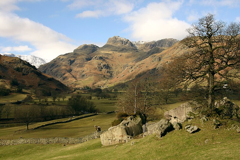
 the view from the south is completely different from the iconic Langdale Valley view


which I don't have a digital version of so here is one by Mark Jobling from Wikipedia.

Tuesday, 5 January 2010

ABC Wednesday - Ysgyryd Fawr

North-east of the town of Y Fenni (known in English as Abergavenny) this hill is a detached outlier of the Black Mountains in the Brecon Beacon National Park, Wales. As can be seen it is owned by part of the National Trust which in Welsh is Yr Ymddiriedolaeth Genediaethol. Yr is 'the' in Welsh and it depends on the following letter or vowel how it is spelt. I can't remember what I read about this and as my ancestors left Wales a hundred years plus ago so no help there.
It is only a little lump of a hill so it is a saunter rather than a walk as Ymlwybro (make one's way) to the top
and what does the trig point say - Skirrid Fawr. Have I taken a wrong turn? Not unusual but not this time, no this is like T S Eliot's Old Possum's Book of Practical Cats, the 'Naming of Cats'

The naming of cats is a difficult matter,
Its not just one of your holiday games;
You may think at first I'm as mad as a hatter
When I tell you, a cat must have THREE DIFFERENT NAMES

Ysgryd Fawr (one name), the anglicised Skirrid Fawr usually just called Skirrid (two) and then Holy Mountain or Sacred Hill (its third name). The welsh Ysgryd describes the hill's shape; that which has shivered or shattered. The end of the hill has sheared off and is a contrast to the gentle sloping path on these photos.

This is how it got its third name. The legend is that the landslide broke off part of the hill as Jesus was crucified, but this is possibly Christianity covering over the older pagan significance connected to the autumn equinox. Whichever, the local tradition meant that the soil was considered to be especially fertile and it was taken away to be scattered on fields, on coffins and the foundations of churches. In days of yore, the Middle Ages, a chapel was built on the top for the pilgrims who were attracted by its religious connections but it has now virtually disappeared without trace.
It is a hill that stands alone which means you get marvelous views. Here looking down the ystrad (vale) and its patchwork fields to the pointy Sugerloaf Mountain and the flatter Table Mountain in the distance. Sugerloaf Mountain has a rather nice vineyard in its environs where you can buy wine and have a pot of tea and yummy cakes under a vine leaved awning. On the hot day we were visiting I could almost imagine I was in Greece but there I would probably have been drinking a chilled Mithos beer.
Returning the way we came on reaching the bottom took our ymoffwys (rest, repose) as we went to have Sunday lunch.

There is a handy car park for this walk taking about a dozen cars by the side of the road running past Ysgyryd, which we did not use on this occasion, because our holiday cottage was nearby, however we past this car park everyday as we journeyed out and back to the cottage and the only time it was ever empty of cars was after 10 at night. A very popular destination.

We could not see Ysgryd from our cottage but we could see the pointy

Sugerloaf.

Isn't the Welsh language useful for having lots of words starting with Y. I will leave with one last word I came across that I rather like and is appropriate for the time of year. In yesterday's post I said that all the snow had gone, today it came back again, and tonight has frozen, so tomorrow I might be doing this. Ysglefrio - to slide on ice.

To visit other participants in the ABC Wednesday meme and their take of the letter Y go here

Tuesday, 28 July 2009

ABC Wednesday - B

B is for Black Combe

My local mountain, or possibly hill as it is only 1,969 ft. Here is the view from Kirkby Moor with a piece of farm machinery, not sure what its original use was for. I am a generation away from my farming roots.
I can't resist a rusting building so here we are moving closer on a beautifully sunny day.
And here closer still from Skelly Crag on the Duddon estuary. This was a very breezy day so the washing at the end house would not take long to dry.

It is a popular walk to the top of Black Combe and can be approached from many directions. You are sure to meet at least one person on the way up, down, or on the top. They are usually walking but depending on the time of day there will usually be someone running. The local fell running club could only be called one thing the Black Combe Runners and there is usually a race at some time of the year here.
Popular also with cyclists, although they are fewer in number. Here is one going up from the north west side which has a lot less distinct path than the wide path from Whicham church. He is heading for the top.
Now I have, somewhere, pictures of the view from the top taken with my old film camera. They are hiding from me. On a clear day it is a fabulous view, out to sea to the Isle of Man and mountains to the north and the Coniston range to the east. I can't find one on the net so this is one taken by stridingedge.net of the trig point on the flat top. This is a good place to shelter from the wind and is a popular place to eat sandwiches and chat to whoever else is passing.
Being near the Irish Sea Black Combe does tend to attract the clouds and there is a saying "If you can see Black Combe it is going to rain, if you cannot see it, its already raining".
It appears and disappears depending on the air quality. This is a hazy view taken yesterday with the north end spit of Walney Island just visible under the hill and the Duddon Sands beyond. It was not visible at all today because, torrential rain, and more forecast tomorrow.

Now a hill like this, that stands alone on a flat plain, does not have only one saying about it, but two, but this one is of an older origin and is "nothing good ever comes round Black Combe". Which could mean our West Cumbrian neighbours, no just kidding, it probably refers to the Scottish raiding parties down from the borders commonly known as the Border Reivers.

For bags more Bs take a trip to ABC Wednesday

Monday, 9 February 2009

Snow


Well at last we got some snow in this little sea-girt corner. The rest of the country seems to have had a ton of it over the past weeks.

Inland the Lake District fells are covered with snow and this has unfortunately kept the Mountain Rescue teams busy, especially in the Langdale/Ambleside area. Someone (Martin Campbell) was filming in the Langdale Valley and caught one of the rescues off Bowfell. See the helicopter.


A lot more snow and ice around in 2009 than on this photo taken at a similar time of year in 2005.


Bowfell
- Climbers' Traverse
Taken by Ann Bowker